 |
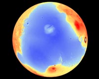
Berkeley CA (SPX) Jun 13, 2007 A paper in this week's issue of Nature by University of California, Berkeley, geophysicists demolishes one of the key arguments against the past presence of large oceans on Mars. Even from Earth, a large plain surrounding the planet's north pole looks like a sediment-filled ocean basin. In the 1980s, Viking spacecraft images revealed two possible ancient shorelines near the pole, each thousands of kilometers long with features like those found in Earth's coastal regions. The shorelines - Arabia and the younger Deuteronilus - date from between 2 and 4 billion years ago. In the 1990s, however, NASA's Mars Global Surveyor mapped the Martian topography to a resolution of 300 meters, and found that the shoreline varies in elevation by several kilometers (more than a mile), rising and falling like a wave with several thousand kilometers from one peak to the next. Because shoreline elevations on Earth, measured relative to sea level, are typically constant, many experts rejected the notion that Mars once had oceans. UC Berkeley scientists have now discovered that these undulating Martian shorelines can be explained by the movement of Mars' spin axis, and thus its poles, by nearly 3,000 kilometers along the surface sometime within the past 2 or 3 billion years. Because spinning objects bulge at their equator, this so-called "true polar wander" could have caused shoreline elevation shifts similar to those observed on Mars. "When the spin axis moves relative to the surface, the surface deforms, and that is recorded in the shoreline," said study coauthor Michael Manga, UC Berkeley professor of earth and planetary science. "On planets like Mars and Earth that have an outer shell, or lithosphere, that behaves elastically, the solid surface will deform differently than the sea surface, creating a non-uniform change in the topography," added primary author Taylor Perron, a former UC Berkeley graduate student now a postdoctoral fellow in Harvard University's Department of Earth and Planetary Sciences. Perron's calculations show that the resistance of Mars' elastic crust could create several-kilometer elevation differences for features like a shoreline, in accord with topographic measurements. The Arabia shoreline varies in elevation by about 2.5 kilometers, while the Deuteronilus shoreline varies by about 0.7 kilometers. "This is a beautiful result that Taylor got. The mere fact that you can explain a good fraction of the information about the shorelines with such a simple model is just amazing. It's something I never would have guessed at the outset," said co-author Mark Richards, professor of earth and planetary science and dean of mathematical and physical sciences at UC Berkeley. Richards goes so far as to add, "This really confirms that there was an ocean on Mars." Richards pointed out that the tilt of the rotation axis of a planet actually remains fixed relative to the sun, but the crust moves relative to this axis. The question remains: What caused Mars' rotation axis to move relative to the crust? Any major shift of mass on a planet - within the mantle, or between the mantle and the crust to form a volcano, or even via impact from outer space - could cause a shift of the rotation axis because a spinning planet is most stable with its mass farthest from its spin axis. Richards has modeled true polar wander in Earth's past that was generated by the upwelling of hot mantle in the interior of the planet, which some scientists claim shifted our planet's rotation axis 90 degrees some 800 million years ago, tipping the planet on its side. Perron, Manga, Richards and their colleagues calculate that on Mars, an initial shift of 50 degrees from today's pole, equal to about 3,000 kilometers on the surface, would be sufficient to disrupt the Arabia shoreline, while a subsequent shift of 20 degrees from today's pole, or 700 kilometers, would have altered the Deuteronilus shoreline. Interestingly, today's pole and the two ancient poles lie in a straight line equidistant from the planet's biggest feature, the Tharsis rise, a bulge just north of the equator that contains Mars' most recent volcanic vent, Olympus Mons. Tharsis is the largest volcano in the solar system, and formed about 4 billion years ago, not long after Mars solidified. Dynamically, the relative positions of Tharsis and the pole path is exactly what would be expected for any mass shift on Mars that is smaller than the Tharsis rise, since the planet would reorient in a way that keeps Tharsis on the equator. "This alignment is unlikely to occur by coincidence," the team wrote. Manga has a hunch about the mass shift that precipitated the tilt of Mars' rotation axis. If a flood of water had filled the Arabia ocean about 3 billion years ago, to a depth some have calculated at up to several kilometers, that mass at the pole might have been enough to shift the pole 50 degrees to the south. Once the water disappeared, the pole could have shifted back, then shifted again by 20 degrees during the deluge that created the Deuteronilus shoreline. Because it's unclear whether the two shorelines represent separate inundations or whether one is the receded shoreline of a larger sea, an alternative scenario features the Arabia ocean receding to the Deuteronilus shoreline, shifting the pole from 50 to 20 degrees. Then, once the Arabia ocean disappears entirely, the pole returns to its current position. Richards is skeptical of this, however, pointing out that thermal convection within the hot interior of Mars could also have caused the poles to wander. "There must certainly be thermal convection in Mars now because Olympus Mons had new lava flows very recently, within the last 100 million years," he said. "But the jury's still out." Manga said, too, that the source of the water, while unknown, must have produced a deluge greater than any observed on Earth, since huge canyons are cut in the flanks of the Tharsis rise. The water may have evaporated, but it may also have sunk back into underground dikes, frozen near the surface but possibly liquid below. The study, whose coauthors include Jerry X. Mitrovica and Isamu Matsuyama, will appear in the June 14 issue of the British journal Nature. Mitrovica, who is with the Department of Physics at the University of Toronto in Ontario, Canada, and was a visiting Miller Professor at UC Berkeley, and Matsuyama, who is with the Department of Terrestrial Magnetism at the Carnegie Institution of Washington in Washington, D.C., have developed models for the effect of polar wander and internal dynamic processes on the surface deformation of Mars. The work is part of UC Berkeley's BioMars project, funded by NASA's Astrobiology Institute. The research also was supported by UC Berkeley's Miller Institute for Basic Research in Science, the Natural Sciences and Engineering Research Council of Canada and the NASA Mars Data Analysis Program. Community Email This Article Comment On This Article Related Links BioMars at Astrobiology Institute Mars News and Information at MarsDaily.com Lunar Dreams and more
 Pasadena CA (SPX) Jun 12, 2007
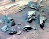
Having completed studies of bright, silica-rich soil deposits at a target known as "Gertrude Weise," Spirit drove to a perch on the eastern edge of the circular, plateau-like feature known as "Home Plate" and began studying its stratigraphy. Spirit will next drive back in the direction of Gertrude Weise to study another nearby outcrop. |
|
| The content herein, unless otherwise known to be public domain, are Copyright 1995-2006 - SpaceDaily.AFP and UPI Wire Stories are copyright Agence France-Presse and United Press International. ESA PortalReports are copyright European Space Agency. All NASA sourced material is public domain. Additionalcopyrights may apply in whole or part to other bona fide parties. Advertising does not imply endorsement,agreement or approval of any opinions, statements or information provided by SpaceDaily on any Web page published or hosted by SpaceDaily. Privacy Statement |