 |
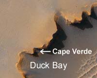
Pasadena CA (JPL) Apr 05, 2008 Opportunity is wrapping up its scientific investigation of the outcrop exposure known as "Gilbert_A" at the bottom of the alcove known as "Duck Bay," the lowest traversable portion of the crater's interior. Duck Bay is a recess in the walls of "Victoria Crater." Opportunity performed a dental self-examination of teeth in the rover's rock abrasion tool on Sol 1482 (March 25, 2008). Images of the grinding bit, taken with the hazard avoidance cameras, showed no appreciable wear since the last measurement on sol 1443 (Feb. 14, 2008). In fact, the rover's handlers saw a slight increase rather than decrease in bit height, highlighting the uncertainty inherent in the bit measurement technique. Indeed, the calculated 32 percent of grinding material left is subject to a 39-percent relative error, resulting in an absolute error of 12 percent (based on a statistical calculation, 0.32 * 0.39 = 12). Unfortunately, there is no clear way to reduce the error in bit measurement. Opportunity is healthy and all subsystems are operating as expected. Energy is currently around 360 watt-hours (100 watts is the amount of energy needed to light a 100-watt bulb for 1 hour). Tau measurement of opacity caused by atmospheric dust is 0.68 (a Tau of zero would correspond to a perfectly clear sky). The dust factor is 0.679, meaning that about 68 percent of sunlight reaching the solar arrays penetrates the coating of dust to generate electricity. Next week, Opportunity is scheduled to drive toward the promontory known as "Cape Verde" for a better look at the rocks exposed in the crater walls. Sol-by-sol summary: In addition to receiving morning instructions directly from Earth via the rover's high-gain antenna, relaying data to Earth each evening via the UHF antenna on the Mars Odyssey orbiter, and completing atmospheric observations that included measuring atmospheric dust with the panoramic camera, monitoring dust accumulation on the rover mast, and scanning the sky for clouds with the navigation camera, Opportunity completed the following activities: Sol 1478 (March 21, 2008): Opportunity spent 12 hours acquiring data from Gilbert with the Moessbauer spectrometer. The rover completed a survey at high Sun with the panoramic camera and went into a mini-deep sleep. Sol 1479: Opportunity spent 12 hours acquiring data from Gilbert with the Moessbauer spectrometer. The rover took thumbnail images of the sky for calibration purposes with the panoramic camera and went into a mini-deep sleep. Sol 1480: Opportunity spent 5 hours acquiring data from Gilbert with the Moessbauer spectrometer and took full-color images, using all 13 filters of the panoramic camera, of the backslope to the left of the Gilbert area. The rover acquired images of the rock target dubbed "Lyell Oxford" and surveyed the horizon with the panoramic camera. The rover went into a deep sleep. Sol 1481: Opportunity spent 7 hours acquiring data from Gilbert with the alpha-particle X-ray spectrometer and took images of Lyell Oxford with the panoramic camera. The rover took six movie frames spaced at regular intervals in search of clouds with the navigation camera and went into a mini-deep sleep. Sol 1482: Opportunity took a microscopic image of the hole ground into Gilbert with the rock abrasion tool and completed a survey of the grinding bit on the tool. Opportunity spent 8 hours integrating data from Gilbert with the Moessbauer spectrometer and went into a mini-deep sleep. Sol 1483 (March 26, 2008): Opportunity spent 7 hours integrating data from Gilbert with the Moessbauer spectrometer and went into a deep sleep. Odometry: As of sol 1483 (March 26, 2008), Opportunity's total odometry was 11,671.23 meters (7.25 miles). Community Email This Article Comment On This Article Related Links Mars News and Information at MarsDaily.com Lunar Dreams and more
 Pasadena CA (JPL) Mar 28, 2008
Opportunity has completed scientific studies of the undisturbed surface of a rock target informally named "Dorsal" in the "Gilbert" rock layer inside "Victoria Crater." Dorsal is a protruding fin of rock created by minerals deposited in cracks that remained in place long after the original rock eroded away because they were more resistant to weathering. |
|
| The content herein, unless otherwise known to be public domain, are Copyright 1995-2007 - SpaceDaily.AFP and UPI Wire Stories are copyright Agence France-Presse and United Press International. ESA Portal Reports are copyright European Space Agency. All NASA sourced material is public domain. Additional copyrights may apply in whole or part to other bona fide parties. Advertising does not imply endorsement,agreement or approval of any opinions, statements or information provided by SpaceDaily on any Web page published or hosted by SpaceDaily. Privacy Statement |