 |
Pasadena CA (JPL) Jan 28, 2008 During four months prior to the fourth anniversary of its landing on Mars, NASA's Mars Exploration Rover Opportunity examined rocks inside an alcove called "Duck Bay" in the western portion of Victoria Crater. The main body of the crater appears in the upper right of this panorama, with the far side of the crater lying about 800 meters (half a mile) away. Bracketing that part of the view are two promontories on the crater's rim at either side of Duck Bay. They are "Cape Verde," about 6 meters (20 feet) tall, on the left, and "Cabo Frio," about 15 meters (50 feet) tall, on the right. The rest of the image, other than sky and portions of the rover, is ground within Duck Bay. Opportunity's targets of study during the last quarter of 2007 were rock layers within a band exposed around the interior of the crater, about 6 meters (20 feet) from the rim. Bright rocks within the band are visible in the foreground of the panorama. The rover science team assigned informal names to three subdivisions of the band: "Steno," "Smith," and "Lyell." This view combines many images taken by Opportunity's panoramic camera (Pancam) from the 1,332nd through 1,379th Martian days, or sols, of the mission (Oct. 23 to Dec. 11, 2007). Images taken through Pancam filters centered on wavelengths of 753 nanometers, 535 nanometers and 432 nanometers were mixed to produce an approximately true-color panorama. Some visible patterns in dark and light tones are the result of combining frames that were affected by dust on the front sapphire window of the rover's camera. Opportunity landed on Jan. 25, 2004, Universal Time, (Jan. 24, Pacific Time) inside a much smaller crater about 6 kilometers (4 miles) north of Victoria Crater, to begin a surface mission designed to last 3 months and drive about 600 meters (0.4 mile). Community Email This Article Comment On This Article Related Links Mars News and Information at MarsDaily.com Lunar Dreams and more
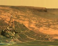
 Pasadena CA (SPX) Jan 04, 2008
NASA'S Mars Exploration Rover Spirit captured this westward view from atop a low plateau where Sprit spent the closing months of 2007. After several months near the base of the plateau called "Home Plate" in the inner basin of the Columbia Hills range inside Gusev Crater, Spirit climbed onto the eastern edge of the plateau during the rover's 1,306th Martian day, or sol, (Sept. 5, 2007). |
|
| The content herein, unless otherwise known to be public domain, are Copyright 1995-2007 - SpaceDaily.AFP and UPI Wire Stories are copyright Agence France-Presse and United Press International. ESA Portal Reports are copyright European Space Agency. All NASA sourced material is public domain. Additional copyrights may apply in whole or part to other bona fide parties. Advertising does not imply endorsement,agreement or approval of any opinions, statements or information provided by SpaceDaily on any Web page published or hosted by SpaceDaily. Privacy Statement |
