 |
Tempe AZ (SPX) Oct 11, 2007 The High Resolution Imaging Science Experiment, or HiRISE, on NASA's Mars Reconnaissance Orbiter has added a new dimension to its views of Mars. The dimension is color. The University of Arizona-based HiRISE team today released 143 color images valuable to researchers studying possible landing sites for NASA's Mars Science Laboratory, a mission to deploy a long-distance rover carrying a deck of sophisticated science instruments on Mars in 2010. The powerful HiRISE camera has taken more than 3,500 huge, sharp images released in black-and-white since it began science operations in November 2006. The camera carries 10 red-filter detectors, two blue-green filter detectors and 10 infrared detectors that record different colors. HiRISE is also releasing a color movie, scrolling over one potential Mars Science Laboratory landing site in Nili Fossae, at 21 degrees north latitude and 74 degrees east latitude. The animation shows a range of enhanced colors that correspond to what Mars Reconnaissance Orbiter's imaging spectrometer, called CRISM, has determined to be hydrated clay minerals and unaltered volcanic rocks. Link to the movie here. "The clay minerals are especially promising in the search for ancient life on Mars," said UA Professor Alfred S. McEwen, HiRISE principal investigator. Beginning this week, images will be released in color as well as black-and-white on the HiRISE Website. The colors are false color, not the way Mars would look to human eyes. The images are processed to maximize color differences, a technique useful for analyzing landscapes. "Color data are proving very useful in interpreting geologic processes and history on Mars," McEwen said. "The images we're releasing today include views of some of the most exciting and compositionally diverse areas on the planet. They are really interesting." In a Herculean effort, HiRISE team members developed computer software that automatically processes images from the different color filters into color images. "The technical hurdle has been that the sets of different color detectors are staggered within the camera focal plane array, and the spacecraft isn't perfectly steady as it operates in space," HiRISE operations manager Eric Eliason said. The spacecraft has excellent pointing control thanks to super engineering, but HiRISE pixels cover an extremely small angular diameter, which gives the camera its ability to sample the surface at 30 centimeters per pixel from 300 kilometers above the surface. The slightest spacecraft motion causes shifts in the camera pointing in unpredictable ways. There's only a split-second time lag between the time each color filter records the same spot on Mars as the camera view sweeps over the planet, but that's enough time for spacecraft motion to knock the colors out of register by up to a few pixels. "You can't just take the different color images and lay them down on each other adjusting only for the slight time lag and get a sharp picture," Eliason said. HiRISE software developer Guy McArthur and applied mathematics undergraduate student Sarah Mattson put a lot of work into developing code that now successfully correlates the data from the different detectors. McArthur developed software that automates color correlation processing at HiROC, the HiRISE Operations Center at the UA. Color is a boon to geologists who have been trying to discriminate different surface materials and their relation to the topography, McEwen said. "Color clearly identifies basic material distinctions like dust, sand or rocks, light-toned layered material, and frost or ice," he said. Color also helps geologists correlate layers in the Martian terrain. And scientists will be able to combine HiRISE data with CRISM data to make detailed maps of minerals and soil types on the planet. A single HiRISE image will often be a multigigabyte image that measures 20,000 pixels by 50,000 pixels, which includes a 4,000-by-50,000 pixel region in three colors. It can take a computer up to three hours to process such an image. McEwen decided to process images that support selection of the Mars Science Laboratory, or MSL, landing site first. "The MSL is holding a landing site workshop later this month, so the color images had to be ready a couple of weeks in advance to be useful," McEwen said. The color images released today were taken over or near about 30 proposed landing sites for the 2010 mission. The UA-led Phoenix Scout Mission to Mars was saved from being launched to a dangerous, boulder-strewn landing site when researchers saw HiRISE images taken soon after the camera began taking science images in late 2006. Images from HiRISE and from Arizona State University's Thermal Emission Imaging System on Mars Odyssey were used in choosing where the Phoenix spacecraft will land on May 25, 2008. McEwen said the HiRISE camera will try to image the Phoenix spacecraft landing site again in January, although it could be so cloudy the camera might have to wait an extra month or two for a clear view. Community Email This Article Comment On This Article Related Links HiRISE Website Mars Reconnaissance Orbiter Mars News and Information at MarsDaily.com Lunar Dreams and more
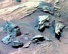 Pasadena CA (JPL) Sep 28, 2007
Spirit completed the rover's longest 5-wheel drive to date en route to a platy rock surface nicknamed "Texas Chili" in an area scientists are calling a "stratigraphic wonderland." The platy outcrop is at site 3 on top of "Home Plate" and is the focus of in-depth scientific investigation. Two sols after not receiving a scheduled data transmission, Spirit drove 19.21 meters (63.02 feet) to the rover's current location about 15 meters (49 feet) away from a field of boulders. |
|
| The content herein, unless otherwise known to be public domain, are Copyright 1995-2007 - SpaceDaily.AFP and UPI Wire Stories are copyright Agence France-Presse and United Press International. ESA Portal Reports are copyright European Space Agency. All NASA sourced material is public domain. Additional copyrights may apply in whole or part to other bona fide parties. Advertising does not imply endorsement,agreement or approval of any opinions, statements or information provided by SpaceDaily on any Web page published or hosted by SpaceDaily. Privacy Statement |

