Using high resolution images from several Mars orbiters, an international team led by the University of Bern has identified a system of fan deltas in southeast Coprates Chasma that record the highest stand of an ancient ocean in Mars Valles Marineris. The geomorphologic structures, preserved today as scarp fronted deposits near the lower end of the canyon system, closely resemble classic river deltas on Earth and mark the point where sediment laden rivers once debouched directly into a standing body of water.
The work focuses on a sector of Valles Marineris, the largest canyon system on Mars, where previous mineralogical studies had already hinted at long lived water activity and possible shorelines. Earlier evidence for former water and a putative ocean in this region came mainly from detections of water altered minerals and from less precise topographic and morphological indicators. The new mapping now provides a clearly defined coastline, demonstrating that a substantial ocean filled the low lying northern hemisphere of Mars roughly three billion years ago.
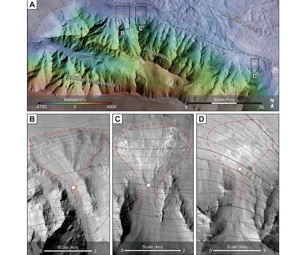
To build this reconstruction, the researchers combined high resolution color and stereo images from several Mars cameras, including the Bern built CaSSIS instrument on ESA s ExoMars Trace Gas Orbiter, as well as data from ESA s Mars Express and NASA s Mars Reconnaissance Orbiter. The team systematically surveyed and mapped the geomorphology of the southeast Coprates Chasma sector, identifying mountains, deeply incised valleys, and sedimentary accumulations that define a coherent depositional system. The CaSSIS images, operating since 2018, supplied key detail for tracing subtle landforms and establishing relative elevations along the inferred shoreline.
According to lead author and doctoral researcher Ignatius Argadestya of the Institute of Geological Sciences and the Physics Institute at the University of Bern, the imagery revealed a landscape with mountain ranges and valleys that closely mirror terrestrial mountain belts. At the foot of one such range, Argadestya recognized a set of fan shaped sediment bodies with steep, scarp like fronts, which the team interprets as fan deltas that prograded into a long lived water body. Fan deltas form where debris and sand carried by rivers and gravity flows accumulate directly into lakes or seas, creating lobate constructs with well defined fronts.
The mapped Martian fan deltas show the same organizing principles seen in Earth analogs, where rivers enter oceans and deposit their load at the coastline. For the Bern team, this similarity strongly supports interpretation of the Coprates Chasma deposits as the preserved mouths of rivers entering a broad ocean basin. As Professor Fritz Schlunegger of the Institute of Geological Sciences explains, the identified structures represent the clear geomorphic expression of river mouths feeding into an ocean, rather than into a small, confined lake.
From the elevation of the delta fronts and associated shorelines, the researchers infer that the ancient ocean filling the northern lowlands of Mars was at least as extensive as the Arctic Ocean on Earth. They emphasize that estimates of a large northern ocean had been proposed before, but those scenarios relied more heavily on indirect arguments and coarser scale data. The new reconstruction anchors the maximum sea level to sharply defined coastal markers resolved in the latest high resolution images, making this the deepest and largest former ocean yet documented on Mars.
The study therefore provides robust evidence that Mars was once a blue planet, with a major ocean occupying much of its northern hemisphere and an active hydrological cycle feeding sediment from high standing terrains into marine basins. Today, the original delta morphologies are partly masked by wind sculpted dunes that drape the deposits and surrounding plains, yet the underlying fan geometries and scarp fronts remain clearly visible. This preservation allows researchers to reconstruct the former shoreline despite billions of years of aeolian reworking.
The confirmed presence of extensive fan deltas and a large ocean has important implications for past habitability on Mars. Long lasting bodies of surface water, coupled with active sediment transport and deposition, create diverse environments where chemical gradients and mineral surfaces can support the emergence and evolution of life. Argadestya notes that while Mars is now a cold, dry, red world, the new results depict an earlier epoch when it more closely resembled Earth, underscoring both the ubiquity and the fragility of surface water on rocky planets.
For the Bern team, the project also demonstrates how terrestrial geological concepts can be transferred to other worlds. The researchers applied a sedimentological approach, comparing depositional environments reconstructed from Mars imagery with well studied Earth analogs to interpret the observed landforms. In particular, they used relationships among source areas, transport pathways, and delta geometries to distinguish marine fan deltas from other sedimentary accumulations.
Looking ahead, the group plans to investigate the mineralogical composition of the ancient Martian soils and sediments associated with the deltas and surrounding terrains. By characterizing weathering products and alteration minerals, they aim to infer the intensity and duration of past water rock interactions, as well as the climatic conditions that prevailed when the northern ocean was present. These constraints will refine understanding of when Mars transitioned from a blue world with active surface water to the arid planet seen today.
The findings are reported in the journal npj Space Exploration under the title Scarp fronted deposits record the highest water level in Mars Valles Marineris. The paper details the geomorphologic mapping, elevation analysis, and comparison with terrestrial analogs that underpin the ocean level reconstruction. The study also highlights the central role of CaSSIS and other high resolution Mars imagers in resolving landforms at scales necessary to detect and interpret subtle coastal indicators.
Research Report:Scarp fronted deposits record the highest water level in Mars Valles Marineris