A view of the red planet almost completely enveloped in dust storms is one of 15,251 newly released images from NASA's Mars Global Surveyor. These images bring the total number of snapshots taken by the spacecraft to more than 93,000.
The latest images to be added to the online archive are from the first phase of the Mars Global Surveyor extended mission, which began February 1, 2001. Regions that were poorly covered during the primary mapping mission due to regional dust storms have now been captured.
The latest images include sand dunes on Mars' north polar cap and a 3-D image of layered rock that resembles the topography of Arizona and Utah.
Also included are two dramatic global views of Mars. The first view shows the modest yet impressive beginnings of a regional dust storm, while the other shows the planet's geographical features almost completely obscured by multiple dust storms.
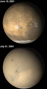
The MGS MOC images showed the evolution of the 2001 great dust storm period. There was never a time when the entire planet was in the midst of a single storm. Several large storms would occur at the same time, and dust was kicked high into the atmosphere to cause much of the rest of the planet to be obscured. The dust storms largely subsided by late September 2001, but the atmosphere remained hazy into November of that year.
The two pictures pictures above come from the E05 (June 2001) and E06 (July 2001) subphases of the MGS MOC Extended Mission. The view from June shows the Tharsis volcanic region (left), Valles Marineris chasms (right) and the late winter south polar cap (bottom). The view from July shows the same regions, but most of the details are hidden by dust storms and haze.